
About the Holiday
Today’s holiday is all about those paper maps that have guided travelers along the trails, roads, highways, and biways as they search for adventure or just need to get from here to there. While the little window of GPS may be more prominent now, there’s nothing like opening the wide vista of a paper map and letting your mind wander to far-off places. Old maps are fascinating too, as they reveal the changes in road systems and population over time. Today, rediscover your local area or take an armchair trip to a new locale through a paper map.
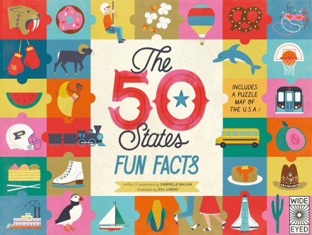
The 50 States: Fun Facts
Written by Gabrielle Balkan | Illustrated by Sol Linero
America is one vast country made up of 50 states that are each unique and fascinating in their own way. The history, people, topography, and even weather of each region has resulted in an incredible diversity of animal life, cuisine, transportation, leisure activities, and celebrations across the nation. The 50 States: Fun Facts offers up a patchwork of engaging and enlightening information about each state that will entice kids to learn more about their own home as well as other areas.

Image copyright Sol Linero, text copyright Gabrielle Balkan. Courtesy of Eyes Wide Editions, Aurum Press.
The large-format board book is divided into five two-page spreads, each dedicated to a particular topic. In 50 Animals readers discover that the first Seeing Eye dogs were trained in Nashville, Tennessee; that “the colors of Maryland’s state cat—the Calico Cat—match the state flag”; and that there are so many moose in Wyoming that there’s even a town named Moose! From state to state kids will also learn about the Chinook Dog of New Hampshire, meet white buffalo that roam North Dakota, and view the state insect of Connecticut—the praying mantis, which can turn its head 360 degrees—among many, many more.
Each state is also known for its own, particular mode of transportation. In Alaska the Tlingit Nation builds beautiful canoes, which the people believe are inhabited by their own spirit. If you’re interested in scanning the skies for alien lifeforms, you may want to head to the San Luis Valley of Colorado, which is considered to be prime UFO-spotting territory! If boats are more your thing, you might want to take a houseboat vacation in the lakes around Jamestown, Kentucky, or see a Navy Destroyer at the shipyard in Bath, Maine. Carousel lovers will want to take the road to Rhode Island, where they can catch the gold ring on the Flying Horse Carousel that has been going round and round for nearly 150 years! There are so many more Things That Go on these pages, including trains, trucks, trolleys, and a 16-story electric shovel!

Image copyright Sol Linero, text copyright Gabrielle Balkan. Courtesy of Eyes Wide Editions, Aurum Press.
After all that activity, readers may be a bit hungry. All they need to do is flip the page to find 50 Things to Eat—specialties from around the nation. Whether you call them blackberries or brambleberries, these sweet nuggets—Kentucky’s state fruit—are great alone or in special treats. If you love pretzels, then the pretzel festival in Germantown, Ohio is for you! Spicy foods more your style? Then you’ll want to check out Hatch, New Mexico—the chili capital of the world! After having Delaware’s chicken specialty, catfish from Mississippi, or potatoes from Idaho, you may just want to try a banana split—first served in Latrobe Pennsylvania in 1904—or even nosh on a few roasted Joshua Tree flower buds that are said to taste like candy.
Ready to work off that meal? The next page provides 50 Ways to Get Moving, including archery in California, rafting in West Virginia, base jumping in Utah, snowshoeing in Minnesota, and snorkeling in Hawaii.

Image copyright Sol Linero, text copyright Gabrielle Balkan. Courtesy of Eyes Wide Editions, Aurum Press.
Celebrations have been part of America since the first Thanksgiving, and each state has a entertaining—often quirky—spectacular to highlight their history or specialty. In Nebraska the old Pony Express mail system is reenacted every June; The Heart of the Ozarks Bluegrass Festival brings musicians and fans to West Plains, Missouri each year; and Honobia, Oklahoma’s Bigfoot Festival makes believers of us all—well, almost.
In Florida, you can learn how to wrestle an alligator with the Miccosukee tribe on American Indian Day; you can test your mettle on 98 flights of stairs during Washington’s Space Needle Base 2 Space Race for charity; and “you can cheer on bronc riders at the ‘Daddy of All Rodeos’” during Cheyenne Frontier Days in Wyoming. Perhaps the oddest celebration is Mike the Headless Chicken Festival held every May in Fruita, Colorado that commemorates “a rooster that lived for 18 months…with no head!”

Image copyright Sol Linero, text copyright Gabrielle Balkan. Courtesy of Eyes Wide Editions, Aurum Press.
Each spread also offers a sidebar scavenger hunt of sorts as it asks readers to see if they can find four different categories of items among the rest. After kids have soaked up all the facts about the 50 states, they can test their knowledge of American geography by completing the included jigsaw puzzle map.
Gabrielle Balkan has collected tons of engaging facts about the United States that are sure to delight and amaze children. Each category would be a wonderful starting point for learning about any or all of the states and gives kids an idea of the variety found across America. Sol Linero’s striking category “quilts,” composed of colorful patches decorated with clear, engaging illustrations, draw readers in to discover the fascinating facts presented about each state.
Ages 4 – 10
Wide Eyes Editions, Aurum Press, 2016 | ISBN 978-1847808691
Discover more about Gabrielle Balkan and her books on her website!
View a gallery of illustration work by Sol Linero on her website!
National Read a Road Map Day Activity

Make a Road Map Jigsaw Puzzle
It’s fun and easy to make your own jigsaw puzzle from a map of your local town or a place you’d like to visit!
Supplies
- A paper map
- Poster board
- Glue or spray glue
- Scissors

Directions
- Smooth out the paper map
- Glue the map to the poster board
- Cut the poster board into interlocking or adjoining pieces (the number of pieces can depend on the child’s age)
Picture Book Review


