
About the Holiday
Sure, GPS can get you where you want to go, but reading a map can show you so much more. Discovering the layout of a town, a state, or even a whole country can be fascinating. Learning the names and locations of towns and cities, rivers and roadways, and forests and mountains isn’t just important for traveling, it can connect you to local and world events, and even give you new insight into history. National Map Reading Week was established in 2016 by the Ordinance Survey, Britain’s national mapping agency, to promote the use of maps and mapping devices so that the skill of map reading is not lost in this age of digital mapping.
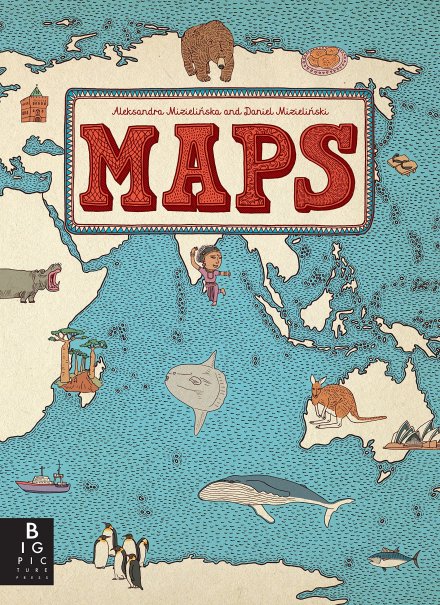
Maps
By Aleksandra Mizielińska and Daniel Mizielińska
The world is a big and intriguing place in this oversized picture book. Forty-two countries are represented within its pages and populated from border to border and even from page edge to edge with cultural, historical, zoological, economic, agricultural, culinary, and linguistic information, all illustrated in stunning thumb-sized detail.
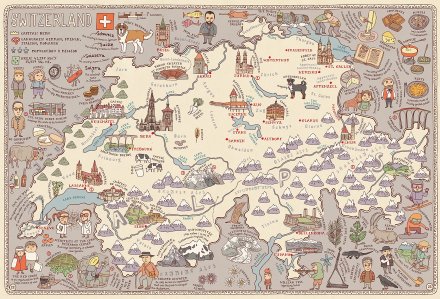
Image copyright Daniel Mizielińska, 2013, text copyright Aleksandra Mizielińska, 2013. Courtesy of Big Picture Press.
Whether you’re casually flipping through the book or examining each page, a colorful or unusual detail will capture your attention and demand a lingering look, which leads to discovering more and more intriguing facts about the towns, forests, mountains, and people who make up each country. Let’s take a peek at a particular town in Switzerland: Appenzel. It’s from here, we discover, that the Appenzeller sheepdog and the Appenzeller cheese round both hail. But what’s this word nearby? Schwingen? And why is it accompanied by two guys wearing their shorts on the outside of their pants? Ah, ha! It’s Swiss Wrestling in which the wrestlers wear special “breeches” with belts that allow opponents to get a good grip for tossing each other around!
Image copyright Daniel Mizielińska, 2013, text copyright Aleksandra Mizielińska, 2013. Courtesy of Big Picture Press.
Mountain lovers will want to flip to the map of Nepal. Home to the Himalayas, which include Mount Everest (the tallest peak on earth) as well as Kangchenjunga, Lhotse, and Makalu (the third, fourth, and fifth highest peaks), Nepal offers plenty of outdoor recreation, including mountain climbing and biking. But visitors to the country’s lakes and rivers must beware of the Mugger Crocodile!
Image copyright Daniel Mizielińska, 2013, text copyright Aleksandra Mizielińska, 2013. Courtesy of Big Picture Press.
For those fascinated by unusual animals, the map of Australia is one to explore. Here readers will find a Superb Lyrebird with a phenomenal tail, sneak a peek at a short-beaked echidna with a spiky coat and a mole-like snout, and learn to duck for a gliding possum. Sports fans can thank Australia for the didgeridoo, and culinary types will appreciate the country’s alternative to peanut butter and jelly: vegemite!

Image copyright Daniel Mizielińska, 2013, text copyright Aleksandra Mizielińska, 2013. Courtesy of Big Picture Press.
There are hundreds of amazing animals, monuments, people, and structures around the world just waiting for you to discover them! The thick, matte, softly muted pages of Aleksandra and Daniel Mizielińska’s Maps are reminiscent of fine cartographers’ volumes, and the intricate mixed-media illustrations are astounding. Both kids and adults will become absorbed in each page and will find themselves doing online searches to learn more about what they see.
Maps is a fantastic coffee table book or home reference for armchair travelers of all ages. It’s also an invaluable resource for teachers and students and would make an often referred to resource in classroom, school, and public libraries.
Ages 5 and up
Big Picture Press, 2013 | ISBN 978-0763668969
National Map Reading Week Activity

Map Jigsaw Puzzle
Sometimes reading a map is like putting together a puzzle—so why not make a puzzle out of a map? It can be fun to use a map of your town or state or to use a map of a state or country you’d like to visit!
Supplies
- Small to medium size map (maps are often offered free at tourist stops, town halls, or other tourist information offices or racks)
- Poster board
- Glue
- Scissors

Directions
- Use the entire map or cut a desired-sized section from a map
- Glue the map to the poster board, let dry
- Cut the map from the poster board
- Cut the map into puzzle sections, these can be straight-sided sections or ones with interconnecting parts.

You can find Maps at these booksellers
Amazon | Barnes & Noble | Books-a-Million | IndieBound
Picture Book Review


